
Image provided by CAL FIRE
By Mary O’KEEFE
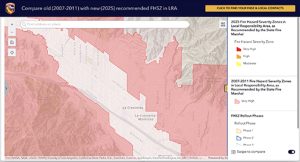
On Monday the Office of the State Fire Marshal (OSFM) released maps referencing the 2025 Recommended Local Responsibility Areas (LRA) Fire Hazard Severity Zone (FHSZ) for Los Angeles County.
These maps are normally updated every 10 years. The maps classify lands within local jurisdictions as being in moderate, high or very high fire hazard severity zones using the latest data on fuels, fire history, weather, terrain and other relevant factors, according to the LA County Fire Dept.
State law requires LA County adopt the recommended maps by ordinance within 120 days from issuance on March 24.
On Monday, LA County Supervisor Kathryn Barger joined LACoFD Deputy Chief Al Yanagisawa to discuss the maps’ release.
“[The maps] are a critical tool for identifying high fire hazard areas and strengthening fire safety policies across our communities,” Barger said. “For those working to rebuild after the Eaton Fire, I want to emphasize that these updated maps provide essential information to guide your rebuilding efforts.”
Barger added the maps reflect fire hazard assessments that will help homes and infrastructures as they are rebuilt to be done so safely with resilience in mind.
LACoFD and LA County Public Works will work to guide homeowners and business owners as they move forward with the new zone designations.
“I encourage everyone, especially those in high fire hazard areas, to review these maps and most importantly stay informed,” Barger added.
“Under government code section 51179B3, a local agency shall not decrease the level recommended by CAL FIRE and [OSFM]; however, the local agency may increase the hazard level or make additions beyond what the state has recommended,” Yanagisawa said.
Since the maps were only recently released, Yanagisawa said County Fire has just started reviewing the information and, as of Monday, did not recommend any additions or increases.
“But that could obviously change as we continue to analyze them,” he added. “We do anticipate a small to moderate increase in the number of parcels but there are areas where the parcels will be reduced.”“Under government code section 51179B3, a local agency shall not decrease the level recommended by CAL FIRE and [OSFM]; however, the local agency may increase the hazard level or make additions beyond what the state has recommended,” Yanagisawa said.
Since the maps were only recently released, Yanagisawa said county fire has just started reviewing the information and, as of Monday, did not recommend any additions or increases.
“But that could obviously change as we continue to analyze them,” he added. “We do anticipate a small to moderate increase in the number of parcels but there are areas where the parcels will be reduced.”
The LA County Board of Supervisors has 120 days to review and make any recommendations. Within those days there will be opportunities for the public to share its opinions.
“I think it’s important to note that with this updated map it does have increased coverage for both high and severely high fire zones in LA County,” Barger said.
During the meeting there was a question about insurance. Many homeowners, and renters, are finding their insurance either dramatically raised or canceled all together due to how they are categorized within fire zones.
“CAL FIRE maps are specifically for hazards. They are developed for us to see where the hazards are currently and they update these maps utilizing past fire history, statistics, weather statistics and fire behavior like fuels, topography and weather,” said Yanagisawa. “They are meant to display where the hazards are. Insurance companies, their modeling and their risk analysis is actually utilizing risk models.”
He added the risk models utilize the same data that CAL FIRE uses for hazard assessment but insurance companies also use different data points.
“They create their own [insurance] system to create their risk analysis,” he added.
Barger said there are ways that people can harden their homes, including incorporating brush clearance, that will help when insurance companies create their policies.
There was another question asking about adding building code requirements due to the new maps zoning designations, and how that may add to the permitting process especially for those rebuilding in fire areas.
Barger said there will be opportunities for people to comment on the maps and hoped that individuals will actually comment during the 120-day period.
The new maps can be found at https://tinyurl.com/bdd6k5nj. The map application allows people to see both the 2024 zones and the 2025 zones.
People are also advised to monitor the LA County Board of Supervisors website at https://bos.lacounty.gov and LA County Fire https://tinyurl.com/5n6w49jj for information on public comment.
Public hearings will be scheduled in LA County to allow for in-person and virtual feedback. CVW will make certain to share the County’s schedule as it is released.
![]()
New Fire Zone Maps Released added by CV Weekly on
View all posts by CV Weekly →