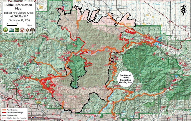
This public information map provides information as of Sept. 29 on areas closed due to the Bobcat Fire.
By Mary O’KEEFE
As of Wednesday morning, the Bobcat Fire burned about 114,202 acres and was 62% contained. There were 1,363 personnel fighting the fire including 119 engines, 23 hand crews, 14 air support, 13 bulldozers and 13 water tenders.
On Tuesday night fire crews focused on strengthening containment lines, monitoring areas for spot fires and looking for opportunities to attack the fire directly. They also continued to mop up and patrol areas near the north end of Mt. Waterman.
The Bobcat Fire began at West Fork of San Gabriel Canyon at Cogswell Dam in the Angeles National Forest. Evacuation orders, as of Wednesday, were in place for Paradise Springs, south of Big Pines Highway, east of Devil’s Punchbowl, west of Largo Vista Road and north of the ANF. In addition, evacuation orders were in place for the south and west areas of Upper Big Tujunga Canyon, east of Angeles Forest Highway and north of Angeles Crest Highway and residents along Angeles Crest Highway between ANF and Highway 29.
As of Wednesday there were several road closures including: Highway 2 [SR2] between ANF Highway and a point 2.2 miles east of the junction with the I-210 freeway. SR2 between ANF highway to Big Pines, ANF highway from Sierra Highway to Angeles Crest Highway, all roads leading into San Gabriel Canyon, Highway 39 is closed north of Azusa to SR 2, Glendora Ridge Road from Glendora Mountain Road to Mount Baldy Road, Upper Big Tujunga Canyon Road from the Crest to ANF highway, Chaney Trail from Alzada Road to Millard Canyon Campground and Chantry Flats, Arno Driver to Forest Route 2N40.
The Red Cross Evacuation Centers at Palmdale High School and Santa Anita Park are now closed. Anyone who still needs assistance is asked to contact Disaster Distress Hotline at (800) 675-5799.
Another fire began on Monday at about 2:50 p.m. at 34577 Bouquet Canyon Road in the Santa Clarita area. Despite “gusty winds” as of Wednesday firefighters have been able to keep the fire contained to 230 acres and containment was at 40%.
According to South Coast Air Quality Management District on Wednesday evening, air quality in the West San Gabriel Valley, including Glendale, Crescenta Valley and La Cañada Flintridge, was considered “Unhealthy for Sensitive Group” with an Air Quality Index Value of 146.
“Members of sensitive groups may experience health effects. This means they are likely to be affected at lower levels than the general public,” according to South Coast AQMD.
